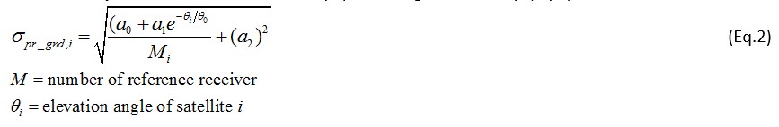
Currently, GPS technology, a part of global navigation satellite system (GNSS), is used to locate each aircraft at various altitudes EXCEPT during approach and landing phases when the air navigation switches to the analog Instrument Landing System (ILS). The next-generation aeronautical navigation system allows the use of GPS technology on the aircraft navigation all the way to runway landing. This is particularly feasible for large aircraft such as Boeing 787 and Airbus 340, therefore, only large airports can accommodate the GPS-based approach and landing.
However, due to positional errors of GPS satellites caused by the fluctuation of total electron content (TEC), which is proportional to the satellite delay, in the ionosphere, the Ground-based augmentation system (GBAS) is introduced to reduce this error which is transmitted to the aircraft. A GBAS system consists of the GNSS-based equipment that broadcasts the augmentation information to the aircraft to correct the errors in GNSS signal-in-space. In GBAS, we have to validate the accuracy, integrity, continuity and availability of system. To fulfill the requirements of ICAO SARPs GBAS standard, every airport needs to construct and verify its own GBAS error model for the installation purpose. Then, the ICAO SARPs’s algorithms are implemented to analyze the maximum protection levels in the normal situation (without ionospheric disturbance nor failed reference receivers) and then analyze the protection levels during ionospheric disturbance events. Besides GPS, ICAO is considering the use of other GNSS technology such as Galileo, Glonass and Beidou satellites for GBAS as well.
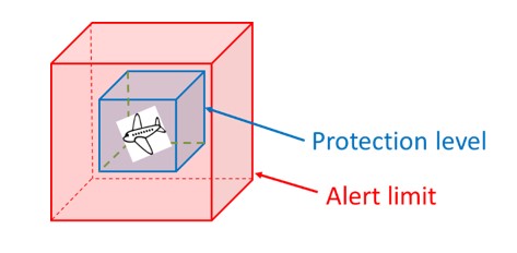
The implementation of GBAS needs to validate 4 reliable parameters: accuracy, integrity, continuity and availability. The algorithms from ICAO SARPs GBAS standard are used to calculate the protection levels. In general, for the aircraft to utilize the GNSS navigation during landing phase, the protection levels (PL), both horizonal and vertical direction cannot exceed the alert limits (AL). The AL depends on the altitudes of the approaching aircraft.
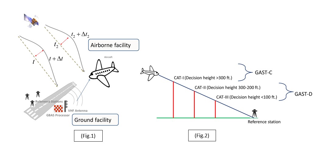
From Fig.1, GBAS ground facility installs 3 or 4 GNSS receiver around airport to receive and calculate the errors in GNSS signal then broadcast the errors to aircraft as augmentation information. Then, the aircraft receives the augmentation information to compensate the error in positioning system. The aircraft has to validate the GBAS reliability by calculating the protection levels.
 |
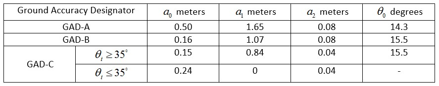
GBAS error model : GBAS error model [2-3], which is used to compute errors in system, is the sum standard deviation of possible types of errors in GBAS. There are 4 types of errors in this model such as ground facility error (pr_gnd), aircraft facility error (pr_air), tropospheric error (tropo) and ionospheric error (iono) as shown below.
![]()
where i represents the i_th satellite.
A. Ground facility error : is an error from the equipment in ground facility.
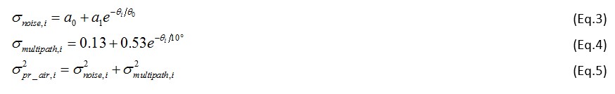
B. Aircraft facility error is an error from the equipment in aircraft facility as shown in Eq. (3)-(5). This error type can be divided into noise and mul-tipath.
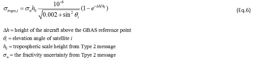
C. Tropospheric error is an error from the troposphere listed in Eq. (6), depending on the altituded of an aircraft
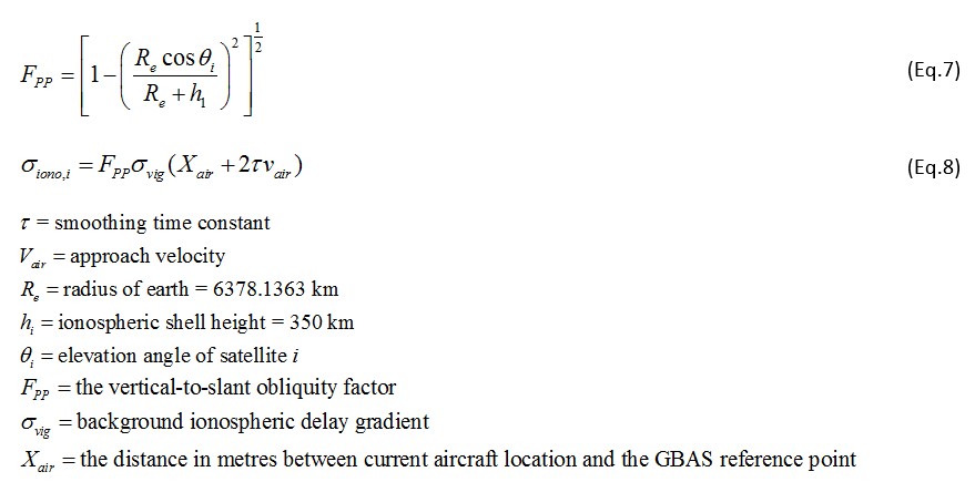
D. Ionospheric error is an error from the ionosphere.
Protection levels & Alert limits
To reach the requirement of GBAS standard, Protection level and alert limit are used to monitor the accuracy of GBAS.
– Protection level is used to limit the positioning error of GBAS system. Protection level can be calculated from tracked satellite geometry and GBAS error model that contain the ionospheric effect.
– Alert limit is a limit of protection level and positioning error. Alert limit are determined by GBAS standard.
References
- P. Enge and P. Misra, “Global Positioning System: Signals, Measurements, and Performance,” Ganga-Jamuna Press P.O. Bpx633 Lincoln, Massachusetts 01773.
- International Civil Aviation Organization (ICAO), “GBAS CAT II/III Development Baseline SARPs,” (Draft proposed changes to Annex 10, Volume I, as agreed at the 17 – 28 May 2010 meeting of the Navigation Systems Panel (NSP) Working Group of the Whole.
- Federal Aviation Administration (FAA), “Minimum Operation Performance Standard For GPS Local Area Augmentation System Airborne Equipment (RTCA-DO253C),” December 16,2008, Washington, DC.