Motivation and Objectives
A satellite-based augmentation system (SBAS) in Fig.
1, the SBAS satellite broadcasts the corrections and integrity to the Global
Navigation Satellite System (GNSS) users to achieve sub-meter positioning
errors. At present, there are SBAS system generations such as L1-SBAS [1] and
DFMC SBAS [2]. However, the first-generation receivers and GNSS satellites have not fully
supported DFMC SBAS. Moreover, the coverage of the ionospheric grid points (IGP) of L1-SBAS (GAGAN) is
only limited to some areas of Thailand as in Fig. 2, but the fast and long-term
corrections of GAGAN SBAS can be utilized at here. Hence, it is still required
to provide a local ionospheric delay estimation method for the L1-SBAS to
improve the GAGAN SBAS user positioning errors.
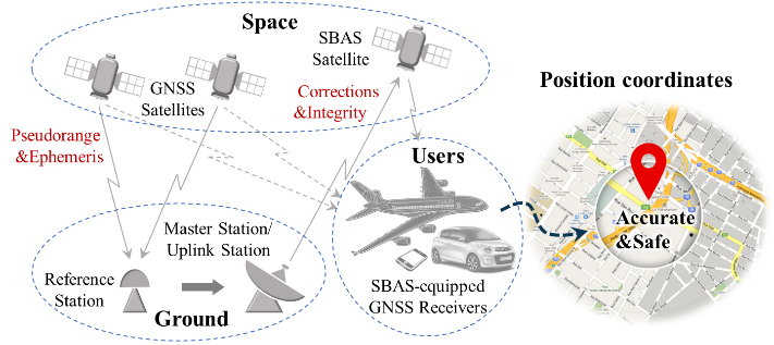
Fig. 1. SBAS operation [3]
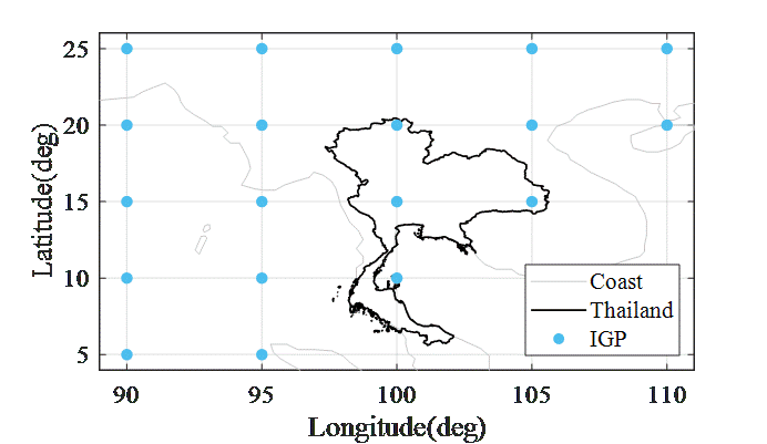
Fig. 2. IGP of GAGAN SBAS.
Objectives
1. To estimate the local ionospheric delays in Thailand by the geo-free ionospheric delay estimation by applying the single frequency (L1) with the fast and long-term corrections of GAGAN SBAS.
2. To evaluate the performances of the proposed method by the user positioning errors based on the single point positioning (SPP) algorithm with observed data in Mach, June, September, and December 2019 from five reference stations in Thailand.
Methodology
As shown in Fig. 3, the local ionospheric delay estimation (δ ̂_viono) is described by three steps. First, the code pseudoranges are smoothed by using the carrier phases to reduce the high noise effects; the pseudoranges of code and carrier phase, and the ephemeris of the L1 frequency are fed as inputs. Secondly, the pseudorange and satellite orbit errors are corrected by applying the fast and long-term corrections of GAGAN SBAS, and the tropospheric delays estimated by the MOPS model as explained. Finally, the local vertical ionospheric delays are estimated based on the proposed method described in [3].
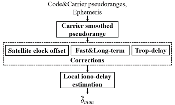
Fig. 3. Block diagram of the proposed local ionospheric delay estimation.
Results
In Fig. 4, the HPE and VPE at the distances of 300 km can be improved by the local ionospheric delays based on the proposed method, with the errors below 1 and 1.5 m, respectively. However, the HPE and VPE at the distances of 550 km are more than 1 and 1.5 m, respectively. Hence, the proposed method is promising for GAGAN SBAS in Thailand.
|
(a) |
(b) |

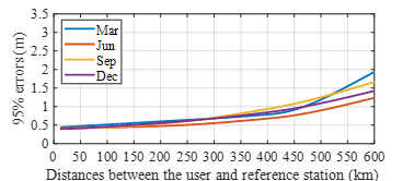
Fig. 4. Horizontal Positioning error (a) and vertical positioning error (b) as a function of distances in March, June, September, and December 2019.
References:
[1] R. DO-229D. (2006). Minimum Operational Performance Standards for Global Positioning System/Wide Area Augmentation System Airborne Equipment. RTCA Inc., Washington, DC 20036 USA.
[2] ED-259A (Draft). (2021). Minimum Operational Performance Standards for Galileo/Global Positioning System/Satellite-Based Augmentation System Airborne Equipment, Version 0.7. The European Organization for Civil Aviation Equipment.
[3] Sophan, S., Phakphisut, W., Myint, L. M., & Supnithi, P. (2021, May). Improvement of Single Point Positioning Accuracy by using GAGAN Satellite-Based Augmentation System in Thailand Region. In 2021 18th International Conference on Electrical Engineering/Electronics, Computer, Telecommunications, and Information Technology (ECTI-CON) (pp. 132-135). IEEE.