Motivation and Objectives
The GNSS satellites are used on or after the approaching phase of the flight to help the aircraft auto-landing system [1]. To ensure with the limits of navigational errors and integrity requirement during approaching and landing, the ground-based augmentation system (GBAS) [2] was proposed as an ICAO standard for the aircraft approaching and landing phases. Normally, in GBAS operation, around three to four reference multi-frequency GNSS stations at the airport compute the pseudo-range corrections based on the potential source of errors around the airport area. The ionospheric delay, the tropospheric delay, and the multipath conditions are the main contributing factors of hazardous positioning errors in the GBAS operation. Therefore, the aircraft positioning errors, both vertical and horizontal axes, estimated with the ground correction service, have to be maintained in an acceptable range for safety [1]. The performance monitoring of the positioning systems is also needed in GBAS. In GBAS, the characteristic of the positioning error due to environmental noise can be calculated from the multipath model [3]. This model requires the satellite elevation angles individually and uses them for the protection level estimation [4]. The standard multipath model is generated by collecting the environmental errors from numerous airports. However, at some airports, they are not located in a perfect condition for the GBAS operation. Therefore, the empirical multipath error may be different from that in the GBAS standard. Moreover, the extended phase of the airport construction can result in different characteristics of the multipath errors from the others. The multipath models from those areas can cause the over-bound or lower-bound of the protection level in the GBAS operations. Therefore, in this work, a curve-fitted model from the different locations around the Suvarnabhumi International airport is introduced. The root-mean-square error (RMSE) is selected to compare the empirical data to each model. The different elevation angles for the comparison are examined to investigate the model improvement.
Methodology
In this work, a curve-fitted model of the multipaths from the different locations around the Suvarnabhumi International airport is introduced. The root-mean-square error (RMSE) is selected to compare the empirical data to each model. The RMSE of different elevation angles are compared to investigate the model improvement. The multipath-related pseudo-range errors are estimated from Iono-free combination, then sliding windows for each satellite are used to compute the standard deviation (STD) from each epoch within about 100-second interval. The grid with a 10-degree resolution of azimuth angle and 5-degree elevation angle for the sky plot is prepared. Each grid selects the empirical data from the STD plots with each azimuth and elevation angle conditions differently. Then the curve-fitting method selects the empirical data to generate the multipath model from each station. Finally, the RMSE is used to compare the empirical multipath errors and each model. Here we consider GAD-B category in this work. This type represents the highest performance of the GNSS receiver without the multipath reduction from the GNSS antenna.
Novelty: (Curve-fitting perspective, Data)
Key Results
|
(a) |
(b) |
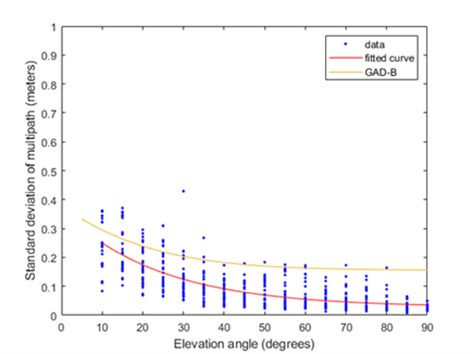
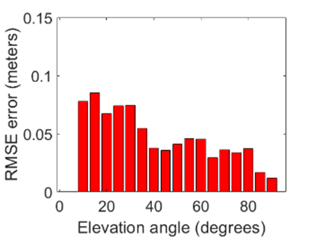
Figure 1. (a) The comparison of the STD of multipath-related pseudo-range errors between the GBAS model and the curve-fitted model, and (b) the multipath RMSE computed between the empirical data curve-fitted model, at AER1 station on February 13, 2019.
We find that the one-dimensional curve-fitting for the multipath model can improve the RMSE at every elevation angle when compared with the GBAS model. From the station with equal distribution of the multipath errors at all azimuth angles, the RMSEs are decreased to less than 0.06 meters, otherwise, the improvement from the proposed method can achieve only below 0.08 meters. Therefore, the two-dimensional model which includes requires azimuth angles can be useful for this type of environment.
References:
[1] E.-114A EUROCAE, “MOPS for global navigation satellite ground based augmentation system ground equipment to support category I operations,” 2013.
[2] ICAO, “Guide for Ground Based Augmentation System implementation,” 2013.
[3] ICAO, “International Standards and Recommended Practices,” in Aeronautical Telecommunications, Annex 10 to the Convention of International Civil Aviation, 2014, vol. 4.
[4] C. Limjumroonrat, S. Rungraengwajiake, P. Supnihi, W. Supanunt, N. Siansawasdi, and S. Saito, “The GBAS protection levels and availability during ionospheric irregularity occurrence,” in 2016 13th International Conference on Electrical Engineering/Electronics, Computer, Telecommunications and Information Technology, ECTI-CON 2016, 2016.