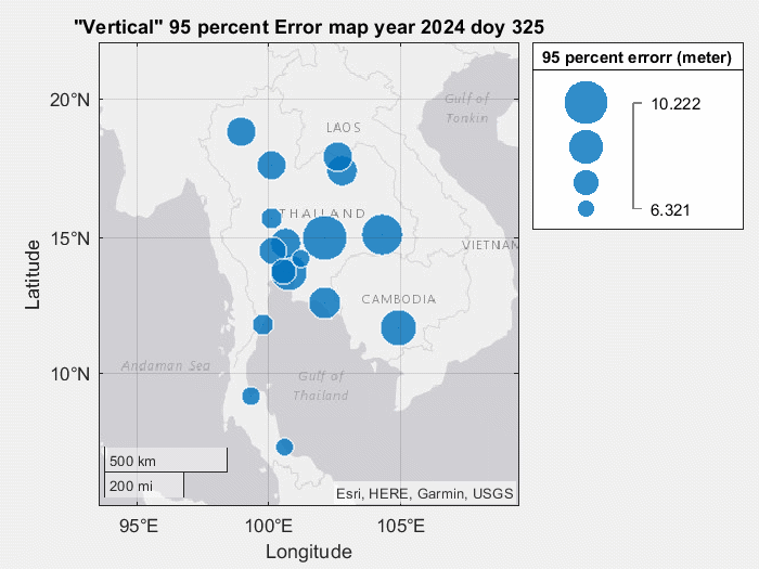
Positioning error map for single-frequency user

Single point positioning using correction model: Klobuchar model (ionospheric delay) and Saastimonen model (Tropospheric model)

Differential TEC (DTEC)

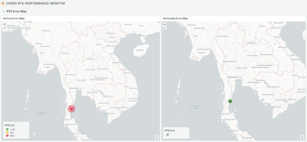
RTK positioning error map

Interpolated TEC map

Radio usable communication

Under updating …

Aerosol Optical Depth (AOD)

Aerosol Optical Depth (AOD) measures how much aerosols in the atmosphere prevent sunlight from reaching the Earth’s surface due to scattering and absorption.

Key Aspects of AOD:

1. Interpretation of AOD Values:

  • AOD = 0: Clear sky with no aerosol presence.
  • AOD < 0.1: Very clean air, minimal aerosol effect.
  • AOD ≈ 0.3 – 0.7: Moderate aerosol concentration, common in urban areas.
  • AOD > 1.0: High aerosol concentration, often due to pollution or dust storms.

2. Sources of Aerosols:

  • Natural: Dust storms, volcanic eruptions, wildfires.
  • Human-made: Industrial emissions, vehicle exhaust, biomass burning.

3. Importance of AOD:

  • Air Quality: Higher AOD indicates poor air quality and health risks.
  • Climate Impact: Aerosols influence Earth’s energy balance.
  • Visibility: High AOD reduces visibility, affecting transportation.

Conclusion: AOD is a crucial indicator for monitoring pollution, climate change, and atmospheric conditions.


Daily AOD from Satellite

AOD Data from ECMWF

The European Centre for Medium-Range Weather Forecasts (ECMWF) provides Aerosol Optical Depth (AOD) data as part of its atmospheric composition modeling and forecasting systems.

Understanding ECMWF AOD Data

ECMWF generates AOD data through numerical models that integrate satellite observations and ground-based measurements. The data is used to analyze and predict aerosol distributions globally.

1. Sources of ECMWF AOD Data:

  • CAMS (Copernicus Atmosphere Monitoring Service): Provides near-real-time AOD forecasts based on satellite and in-situ data assimilation.
  • Reanalysis Data: Long-term datasets offering historical aerosol trends and climatology insights.
  • Global and Regional Models: High-resolution models for weather and climate research.

2. Key Features of ECMWF AOD Data:

  • High Temporal Resolution: Hourly to daily updates for tracking aerosol dynamics.
  • Global Coverage: Data spanning from regional to worldwide aerosol distributions.
  • Multi-Sensor Integration: Incorporates satellite-derived aerosol information for enhanced accuracy.

3. Applications of ECMWF AOD Data:

  • Air Quality Monitoring: Helps detect pollution hotspots and transboundary haze transport.
  • Climate Studies: Contributes to climate modeling by assessing aerosol radiative effects.
  • Weather Forecasting: Enhances numerical weather prediction by considering aerosol-cloud interactions.

Conclusion: ECMWF AOD data plays a vital role in understanding atmospheric aerosols, improving air quality predictions, and supporting climate research worldwide.

Credit

Google Earth Engine (GEE):
Gorelick, N., Hancher, M., Dixon, M., Ilyushchenko, S., Thau, D., & Moore, R. (2017). Google Earth Engine: Planetary-scale geospatial analysis for everyone. Remote Sensing of Environment, 202, 18–27. https://doi.org/10.1016/j.rse.2017.06.031
Data source: ECMWF/CAMS/NRT
Data band: total_aerosol_optical_depth_at_550nm_surface

ECMWF:
European Centre for Medium-Range Weather Forecasts (ECMWF). https://www.ecmwf.int/

AOD Data from MODIS

The Moderate Resolution Imaging Spectroradiometer (MODIS) aboard NASA’s Terra and Aqua satellites provides Aerosol Optical Depth (AOD) data to study atmospheric aerosols on a global scale.

Understanding MODIS AOD Data

MODIS collects AOD data using multi-spectral imaging, measuring how aerosols scatter and absorb sunlight at different wavelengths. This data is essential for monitoring air pollution, climate change, and atmospheric composition.

1. Features of MODIS AOD Data:

  • Global Daily Observations: MODIS provides near-daily aerosol monitoring worldwide.
  • High Spectral Resolution: Measures AOD across multiple wavelengths to improve accuracy.
  • Multi-Sensor Compatibility: Complements data from other satellites like VIIRS and MISR.

2. MODIS AOD Products:

  • MOD04 (Terra) & MYD04 (Aqua): Standard AOD products derived from MODIS.
  • Dark Target Algorithm: Retrieves AOD over oceans and vegetated land surfaces.
  • Deep Blue Algorithm: Enhances aerosol retrieval over bright surfaces like deserts.

3. Applications of MODIS AOD Data:

  • Air Pollution Monitoring: Identifies aerosol hotspots and tracks pollution transport.
  • Climate Change Studies: Assesses aerosol radiative forcing and cloud interactions.
  • Wildfire and Dust Storm Detection: Helps in early warning systems for extreme aerosol events.

Conclusion: MODIS AOD data is crucial for understanding global aerosol distribution, improving air quality assessments, and supporting climate and weather research.

Credit

Google Earth Engine (GEE):
Gorelick, N., Hancher, M., Dixon, M., Ilyushchenko, S., Thau, D., & Moore, R. (2017). Google Earth Engine: Planetary-scale geospatial analysis for everyone. Remote Sensing of Environment, 202, 18–27. https://doi.org/10.1016/j.rse.2017.06.031
Data source: MODIS/061/MCD19A2_GRANULES
Data band: Optical_Depth_047

MODIS (NASA):
Justice, C. O., et al. (1998). The Moderate Resolution Imaging Spectroradiometer (MODIS): Land remote sensing for global change research. IEEE Transactions on Geoscience and Remote Sensing, 36(4), 1228-1249.

AOD Data from Sentinel-5P

The Sentinel-5 Precursor (Sentinel-5P), launched by the European Space Agency (ESA), provides high-resolution Aerosol Optical Depth (AOD) data to monitor air quality and atmospheric pollution.

Understanding Sentinel-5P AOD Data

Sentinel-5P carries the TROPOMI (TROPOspheric Monitoring Instrument), which detects aerosols by measuring sunlight absorption and scattering in various spectral bands. It enables detailed tracking of global aerosol distributions.

1. Key Features of Sentinel-5P AOD Data:

  • High Spatial Resolution: Provides aerosol data at 3.5 × 7 km per pixel.
  • Daily Global Coverage: Captures near-real-time data for improved air quality analysis.
  • Multi-Spectral Observations: Measures aerosols in UV, visible, and near-infrared bands.

2. Sentinel-5P AOD Products:

  • TROPOMI Aerosol Index (AI): Detects absorbing aerosols such as smoke and dust.
  • Aerosol Layer Height (ALH): Provides information on the altitude of aerosol layers.
  • AOD Measurements: Derived from reflectance data over land and ocean.

3. Applications of Sentinel-5P AOD Data:

  • Air Quality Monitoring: Identifies pollution levels in urban and industrial areas.
  • Climate Impact Studies: Assesses the role of aerosols in radiative forcing.
  • Extreme Event Detection: Tracks volcanic eruptions, wildfires, and dust storms.

Conclusion: Sentinel-5P AOD data is essential for air pollution analysis, climate research, and improving atmospheric models for better environmental management.

Credit

Google Earth Engine (GEE):
Gorelick, N., Hancher, M., Dixon, M., Ilyushchenko, S., Thau, D., & Moore, R. (2017). Google Earth Engine: Planetary-scale geospatial analysis for everyone. Remote Sensing of Environment, 202, 18–27. https://doi.org/10.1016/j.rse.2017.06.031
Data source: COPERNICUS/S5P/NRTI/L3_AER_AI
Data band: absorbing_aerosol_index

Sentinel-5P (ESA):
Copernicus Sentinel-5P TROPOMI.
https://sentinels.copernicus.eu/web/sentinel/missions/sentinel-5p

Scroll to Top